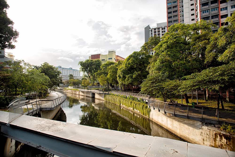
In France, 1 in 4 people and 1 in 3 jobs are exposed to the risk of flooding, through overflowing watercourses or rising sea levels[1]. In more general terms, floods are a major natural hazard in several regions of the world. These risks are now accentuated by climate change and the increase in extreme weather episodes, including intense rain events in particular. In an urban environment, characterised by a strong increase in soil impermeability, these phenomena promote runoff and associated pollution and lead to congestion and flooding. In addition, urbanisation in flood-prone areas is a major economic and social issue for local communities. To meet these challenges, new approaches are being developed to provide better ways of living with water in cities.
Reconstructing a water cycle in an urban environment
To reduce the magnitude of impacts, cities are now adopting at-source stormwater management approaches aimed at maximising the absorption of rainfall by the environment and at recreating a water cycle in urban areas. The aim is to preserve or restore spaces that enable the natural flow of water and thus limit runoff. Cities are adapting in order to minimise changes to the functioning of natural hydro-systems wherever possible.
In China, in late 2014, the government launched the national “Sponge Cities” program aimed at restoring the permeability of some thirty target cities. These pioneering cities are testing various types of development, aimed mainly at increasing the water absorption capacity and preventing saturation in the pipeline networks: valleys, rain gardens, low-pressure areas, green roofs, urban water bodies, porous coatings, transition to permeable car parks, multi-use retention basins, etc. The goal? By 2030, 80% of the surface area of these cities must incorporate facilities that promote the absorption, retention, storage, purification, drainage and reuse of 70% of the rainwater that affects them.
In France, in the same year, the Greater Lyon council started its “Permeable City” project to evaluate alternative techniques for managing rainwater in public spaces. Three years later, the city published a “design and maintenance guide” to raise awareness among local stakeholders and encourage the inclusion of stormwater management concepts in development projects.
Research programmes are being developed at neighbourhood level, such as
MYSTIC, the fruit of a partnership between IFSTTAR, EPA Paris-Saclay and Cerema. The project aims to better understand and assess the impact on the water cycle of changes at city district level, with the urban campus located in the Moulon district on the Saclay plateau being used as a case study. The aim is to observe the effects of the construction of the ZAC (mixed-development zone) on runoff water and on the surface water table. To do this, a 3D geological model of the local area has been constructed: surface water levels have been monitored continuously since 2012; and a detailed and integrated hydrological model has been implemented to simulate the interactions of various planning programmes. Development will continue on the research model to simulate the impact at the end of the development.
Rainwater becomes a resource
Thanks to this type of program, the outlook on rainwater is changing: often perceived as a nuisance and a source of flooding, it becomes a resource that can be reused for plant watering, cleaning or sanitary water. The issue is a crucial one because of cities’ growing vulnerability to drought at certain times of the year, leading to risks of water scarcity.
To be reused, the water can be channelled into watertight underground basins, which act as a cistern from which water is drawn to water plants or to clean a street, for example. Old infrastructures can also be reused for this purpose. This is what has been done on rue Garibaldi in Lyon, where an old bunker (a tunnel in proximity to a road junction) has been preserved and closed, and is now used as storage for rainwater. The water supplies street sweepers for cleaning the roads, and is used for watering trees during heat waves in order to ensure continuous evapotranspiration and the local cooling of the atmosphere. Without this device, during a heat wave, trees stop evapotranspirating to avoid becoming dehydrated, yet this is precisely when their cooling power is needed most.
Take the risk of flooding into account in urban planning
Changing the city’s relationship with water also means taking the risk of flooding into account in urban planning. In 2015, the European Center for Flood Risk Prevention (CEPRI) identified several
planning principles to guide communities and professionals in relation to urban renewal projects in flood-prone areas.
In the case of a flooding river, one of the challenges in dense urban spaces is to give more space to the water to allow flood control; i.e. to attenuate the phenomenon. In the Matra district, in Romorantin, located alongside a river, water is a component of the district’s landscape, providing a visual means of helping to prevent risk. If flood warning levels are exceeded, a public park/retention basin provides a visual alert. Everything has been designed to give residents time to watch the water rise, organise themselves and make decisions. For example, a network of pavements and elevated passages enable them to leave their homes in the event of a flood.
In order to avoid reducing the costs associated with the construction of dedicated water management infrastructure, a growing number of projects are incorporating multifunctional spaces that can switch to crisis mitigation use in the event of a flood. One example of this is the Benthemplein watersquare in Rotterdam. This public square, made up of three large pools, is used in dry weather as a basketball court, skate park or amphitheatre, and allows water to be retained during periods of intense rain. The project was designed with the involvement of users of adjacent facilities (college, church, theatre) and residents. It maximizes the impact of the investment by enabling rainwater to be stored, improving the quality of urban public space and bringing an educational dimension to the function of the watersquare.
Other principles exist: locate activities and urban infrastructures while taking into account their vulnerability to the risk of flooding, design buildings or infrastructures that are suited to the presence of a flood risk in their local area (“amphibian” buildings, construction on stilts, floating buildings), and ensure that technical networks are able to continue operating. The combination of all these drivers helps to strengthen the resilience of a local area or a project in the event of a flood.